Map of Tufts College in 1938. In the lower right corner, you can see the new Cousens Gym north of College Avenue the rest of the undeveloped Stearns Estate. The building to the west of Cousens Gym was originally College Station, but at this time it had been home to Tufts University Press for some time.
Map of Tufts College in 1929, less than a decade after the Stearns mansion was torn down. In the lower right is College Avenue, labeled "To Willows + Medford," referring to the street's nickname. Arrows also indicate that the Site for New Gym and the Tufts College Press are located to the right of the railroad.
Photograph of Eaton Hall in the winter in 1950. Eaton Hall served as the library from its construction in 1908 until the construction of Wessell Library in 1964. The busts of John Brown and George L. Stearns were at one point on exhibit here at one point..
View of College Hill and Tufts College from the Stearns Estate across the railroad tracks to the east. The buildings are, left to right: East Hall, Ballou Hall, Packard Hall, and West Hall.
Photograph of Ballou Hall, the first building on the campus of Tufts College, 6 years after it was opened. Until East Hall was constructed in 1860, Ballou Hall was the college's only building and it provided space for classrooms, a dormitory, a chapel, and a library. Originally called simply College Hall, Ballou Hall was renamed after named after Hosea Ballou II, the college's first president.
Black-and-white photograph of an untitled oil-on-board painting known as "College Hill from Medford," attributed to Benjamin Champney, ca. 1865 (Tufts University Permanent Collection AI 07400). The painting shows the Paul Curtis house and Ballou Hall of Tufts College in the distance, as seen from north of the Mystic River, ca. 1855.
Goddard Chapel soon after it was constructed on the campus of Tufts College, 1883. By the end of the 19th century, a plaque commemorating Dr. Edwin Hubbell Chapin had been placed inside the chapel, where it remains today.
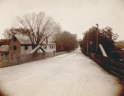
Photograph of College Station at the corner of the Boston & Maine Railroad (foreground) and College Avenue (left). When the new Tufts College Station was built to the south, this building became occupied by Tufts College Press.
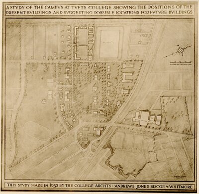
Map of Tufts College showing buildings present in 1932 and possible sites of future buildings. In the lower right quadrant, note the presence of the Physical Education Building (Cousens Gymnasium) and possible future additions northwest of College Avenue, as well as a large plot of the Stearns Estate yet undeveloped. In 15 years, this property would be home to Stearns Village.
Attribution:
College Architects: Andrews, Jones, Biscoe & Whitmore
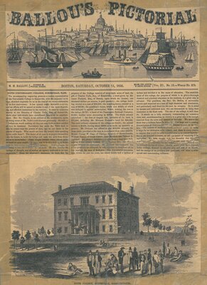
Ballou's Pictorial, printed by M. M. Ballou in Boston, Saturday, October 11, 1856 (Vol. XI, No. 15). The front page article shows a sketch of Tufts College (Ballou Hall) and a short article about the first anniversary of the Universalist Tufts College, quoting Dr. Edwin H. Chapin.
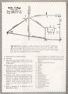
A map of Tufts College about ten years after it opened, from a map drawn by Charles E. Fay, with a key to the buildings given below the map. Note College Hill Station (building W) at the corner of the Boston & Lowell Railroad and College Avenue leading to the Stearns Estate just off the edge of the map. This map appeared on page 148 of The Tuftonian, Vol. 2, No. 4 (May 1942).
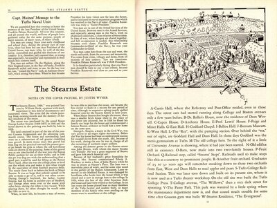
Article titled "The Stearns Estate" by Justin Wyner, describing the 'Stearns Estate, 1899' painting by William Hauk. This article was published on pages 10-11 of the Spring 1945 edition of the Tuftonian. A black and white copy of the painting was featured on the front cover.