Map of Tufts College in 1938. In the lower right corner, you can see the new Cousens Gym north of College Avenue the rest of the undeveloped Stearns Estate. The building to the west of Cousens Gym was originally College Station, but at this time it had been home to Tufts University Press for some time.
Photograph of College Station at the corner of the Boston & Maine Railroad (foreground) and College Avenue (left). When the new Tufts College Station was built to the south, this building became occupied by Tufts College Press.
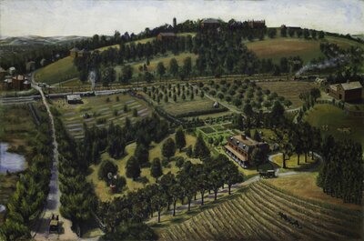
This painting shows the Stearns mansion in the center right and the farmhouse to the far right. In the distance on the hill are the buildings of Tufts College, with the tower of Goddard Chapel, East Hall, and West Hall visible through the trees. The road to the left is College Avenue; at the time it was known as the Willows because of the trees on either side. At the corner of College Avenue and the railroad tracks is College Hill train station. The Boston & Lowell Railroad operated on the tracks that separated Tufts College from the Stearns Estate's orchards.
Attribution:
William Hauk
Attribution Statement:
Image courtesy of the Tufts University Permanent Collection
Map of Tufts College in 1929, less than a decade after the Stearns mansion was torn down. In the lower right is College Avenue, labeled "To Willows + Medford," referring to the street's nickname. Arrows also indicate that the Site for New Gym and the Tufts College Press are located to the right of the railroad.
View towards Medford Square from the top of College Hill (Tufts College), ca. 1910. The tree-lined Avenue stretching left to right is College Avenue, also known as The Willows. The Boston & Maine Railroad parallels the bottom of the image, with College Hill Station appearing at the bottom left. Behind the station is Pansy Park, a pansy nursery. To the left of Pansy Park is property belonging to the Stearns Estate. Across College Avenue are the clay pits.